


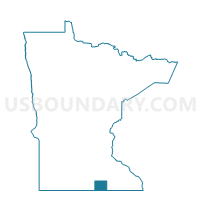
Myrtle Voting District, Freeborn County, Minnesota
About
Outline

Summary
| Unique Area Identifier | 602000 |
| Name | Myrtle Voting District |
| County | Freeborn County |
| State | Minnesota |
| Area (square miles) | 0.11 |
| Land Area (square miles) | 0.11 |
| Water Area (square miles) | 0.00 |
| % of Land Area | 100.00 |
| % of Water Area | 0.00 |
| Latitude of the Internal Point | 43.56313210 |
| Longtitude of the Internal Point | -93.16314360 |
Maps

Graphs
Select a template below for downloading or customizing gragh for Myrtle Voting District, Freeborn County, Minnesota


Neighbors
Neighoring Voting District (by Name) Neighboring Voting District on the Map
- London Twp. Voting District, Freeborn County, MN
- Shell Rock Twp. Voting District, Freeborn County, MN
Top 10 Neighboring County Subdivision (by Population) Neighboring County Subdivision on the Map
- Shell Rock township, Freeborn County, MN (427)
- London township, Freeborn County, MN (315)
- Myrtle city, Freeborn County, MN (48)